Nexus 800
LiDAR / Photogrammetry UAS Solution

“Nexus: a connection of series of connections linking two or more things”

The full end-to-end solution that represents a new paradigm in UAV data collection by seamlessly harmonizing LiDAR data with photogrammetry. The Nexus 800 is a turnkey system that tightly integrates hardware and software to provide a cutting-edge solution for LiDAR survey planning, data acquisition, post processing and analysis, and product creation.
Its foundation is built upon the underlying principle of turning data into tangible information by leveraging the power of real time sensor fusion. Marrying LiDAR sensing and photogrammetry simultaneously limits the “dead time” by streamlining the process of transforming data to meaningful models of the landscape.
Once all the necessary data has been acquired from a flight, Hypack software is utilized to rapidly process it. The software automatically registers any spatially referenced images to build a 3D model, which can then be exported into several different formats as required.
The NEXUS 800 UAS is highly effective in applications where turn around time is paramount such as:
• When you need to see real time data quality
• When you need to see how much coverage you are attaining
• When you want to minimize post processing time
• When you need continuous operations and better situational awareness
• When you need actionable intelligence as soon as possible
Designed and supported by best of brands

Designed and supported by: Infinite Jib™ Inc., HYPACK, a Xylem Brand, SBG Systems, and Velodyne LiDAR.
The Nexus 800 UAS payload includes:
• Velodyne Puck Lite (16 Channel)
• FLIR Vue Pro Thermal Camera
• SBG Ellipse-D Dual GNSS Inertial Navigation System
• RGB Camera
• HYPACK/HYSWEEP
• Hi-performance on-board computing with the Intel
Core i7 16GB RAM/512GB
The Great Debate … LiDAR versus Photogrammetry

Presidential Debate: Donald Trump vs Hilary Clinton
The current debate in the UAV marketplace pits the merits of photogrammetry against the values gained using LiDAR technology. Our approach has been that these tools should not be mutually exclusive rather are complimentary. Clearly the greatest value to be gained is when both technologies are leveraged and this is precisely what the Nexus 800 UAS delivers.
What the Nexus can do that others can’t:
Real time data acquisition / Real time telemetry / Streamlined data processing
True multi-sensor support
Full software pipeline
Industry leading support!
New paradigm- seamlessly harmonizing LiDAR data
with photogrammetry

The Nexus 800 multi-sensor design philosophy tightly integrates hardware and software delivering functionality required for critical projects demanding accuracy and efficiency.
Some of the key capabilities of the Nexus 800 UAS are:
• LiDAR and Photogrammetry mapping UAS
• Data Collection, Processing, Real Time Data Visualization aboard aerial platforms
• Complete GNSS aided inertial navigation system
• Single/Dual LiDAR return with a 360-degree field of view
• Real-Time Image and Point Cloud viewing
• Correlation of Point Cloud and geo-referenced imagery via post processing
• On-board Windows® PC for rapid data acquisition
• Hypack software provides volume computation and data analysis provides the user with powerful tools to produce high quality datasets through a full featured point cloud processing modules that allow the user to edit, manipulate, and produce industry standard product outputs such as LAS or XYZ
• Highest wind resistance of any LiDAR UAS so you stay on schedule and fly when you need to fly
• Redundant safety features
• Full waypoint navigation
Nexus 800 UAS Emergency Survey
Oroville Dam Event 2017
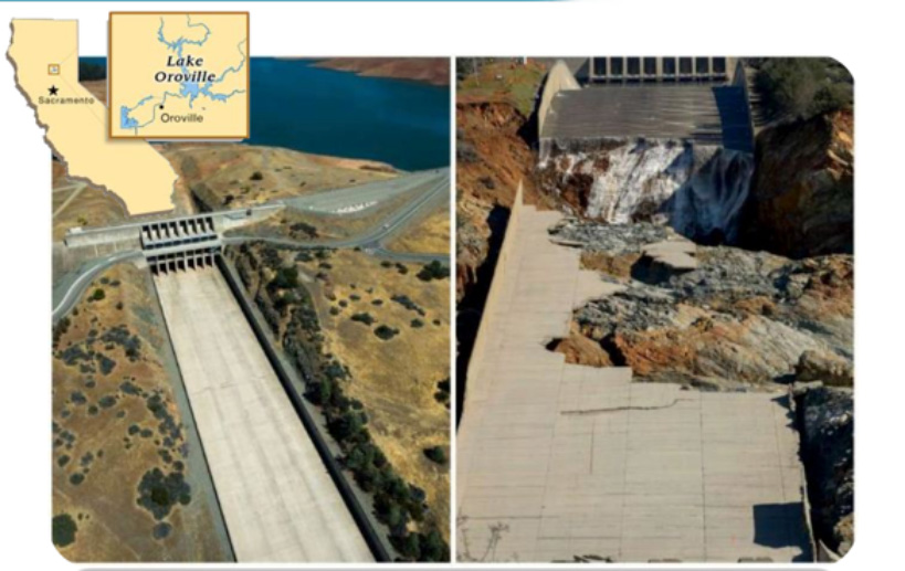
February 2017: Failure of the Main and Emergency Spillways
Photo: Kelly M. Grow/DWR, Brian Baer/DWR
In 2017, extreme flooding events in California took its toll on the state’s water infrastructure. When the Oroville Dam event required an immediate and timely survey to assess damage, emergency response teams turned to the surveyor and engineers to provide the necessary technical expertise to properly mitigate the event. But who do professional surveyors and engineers turn to when they need access to survey grade data in times of need? They turn to tools that they can trust because lives can literally depend on it.
The Nexus 800 Unmanned Aerial System (UAS) was built as a tool to handle these scenarios to quickly turn data into information. Additionally, the Nexus 800 puts an emphasis on performing real time sensor fusion. Simply put: “its all about the data.” So, when licensed professional surveyors and engineers from eTrac (California), SurvTech Solution (Florida), needed an aerial solution, they leveraged the Nexus 800 to attain survey grade LiDAR data that was expeditiously processed and disseminated to the mitigating teams for action. The project required the expertise of an advanced pilot familiar with operating Infinite Jib™ aircraft. Stephen Perry, Civil Engineer and President of Brunswick Engineering, New Brunswick, Canada was called upon to lead the flight crew.
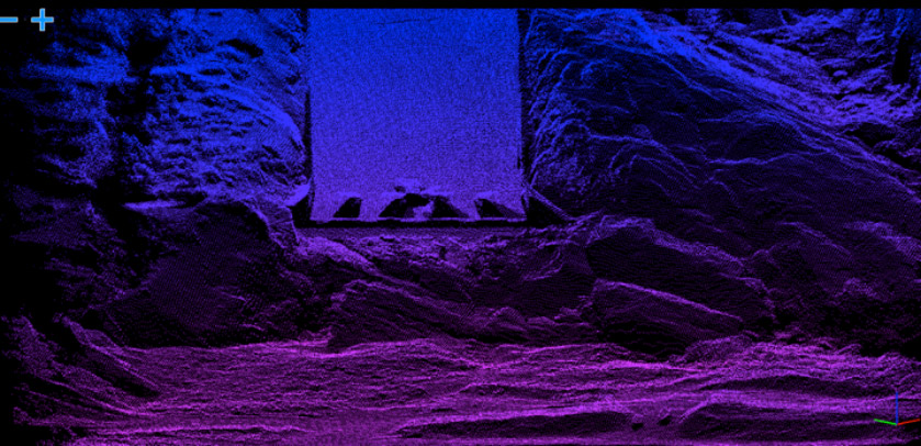
Due to the complexity of the terrain, the team utilized the real time capabilities of HYPACK software to monitor and respond accordingly through the used of the HYPACK Matrix and Real Time Cloud modules to safely navigate the terrain. This increased situational awareness and real time feedback allowed the team to perform multiple sorties safely and efficiently. The surveyor operating under CFR 15 Part 107 also effectively integrated themselves into airspace with other aircraft and heavy lift Skycranes.
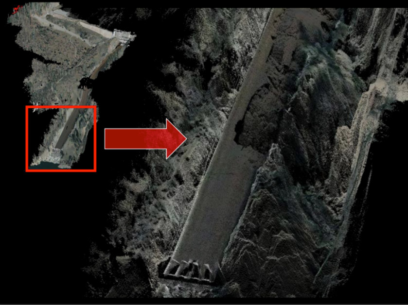
Once on the ground the team utilized HYPACK’s end to end software pipeline, rapidly processing the data and utilizing HYPACK’s latest capabilities that will automatically register any spatially referenced imagery to colourize the LiDAR point cloud which can then be exported into many formats such as LAS version 1.4 in the following example’s, a data comparison is depicted highlighting some of the information that can be garnered from the dataset.
Oroville Dam Emergency Spillway Damage
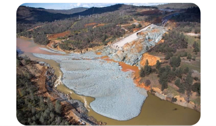
By: CALIFORNIA DEPARTMENT OF WATER RESOURCE
(Dale Kolke/California Department of Water Resource)
Oroville Dam Event – Challenging Terrain
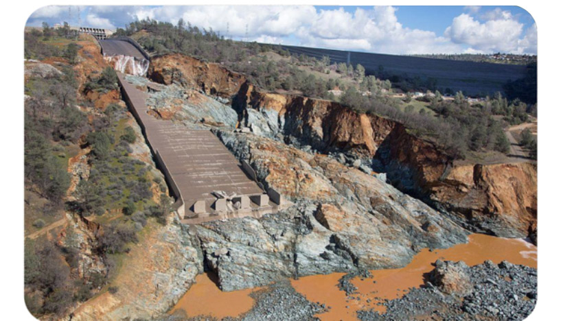
Credit: California Department of Water Resources
http://pixel-ca-dwr.phtoshelter.com/galleries/C0000OxvlgXg3yfg/G00003YCcmDTx48Y/Oroville-Spillway-Incident,Public Domain
Proudly made in Canada
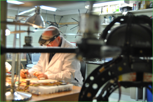
Designed, manufactured and serviced in North America for exclusively for commercial applications, affords you direct technical support and service from your UAV manufacturer. We are a dedicated, specialized company that was founded in 2010. Over the years, we have become known for the exceptional performance of our aircraft, for providing prompt and effective support as well as for the genuine quality of our service.

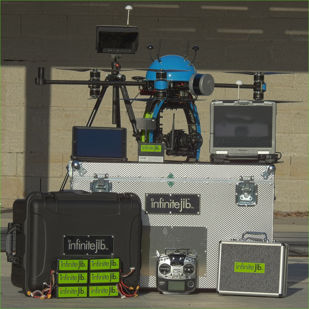
Nexus Aircraft System Component List
The Nexus 800 UAS is a comprehensive system built for the
professional pilot & crew:
• Nexus 800 Y6 Coaxial Airframe (Craft dimensions: 120cm Width x 50cm Height)
• Window 7 Pro on-board computer with dual core i7 2.5 Ghz, 500 Gb of storage, 16Gb Ram, Gig Ethernet, USB 3.0
• Velodyne Puck LITE LiDAR sensor, FLIR Vue Pro thermal camera and Canon camera. This sensor package provides the user with flexibility to operate each sensor individually or in combination to produce data products.
• Panasonic Toughbook CF-30 is provided to remotely control the on-board CPU running HYPACK software
• HYPACK(r) MAX-HYSWEEP software (version 2017) with 1-year subscription to HYPACK maintenance plan.
• SBG ELLIPSE -Dual Antennae INS System with RTK options via NTRIP (separate NTRIP account required) or link to GPS base station.
• Digital data link with extended range provides bandwidth provides secure remote access to the on-board CPU. This data link allows the sensor operator to view and control the airborne sensor as if it was on the ground next to them.
Infinite Jib™ systems feature a commercial grade flight control software that we selected due to its software options, ease of use and proven reliability. Flight control system provides manual control as well as auto takeoff and landing, position hold and return to home location as well as waypoint flight programming.
Futaba 14SG as the standard RC Transmitter selected for Infinite Jib™ systems due to the following:
• Durable construction of the unit, designed for operations in extreme conditions
• Control sticks use high quality potentiometers to accurately represent the pilot’s inputs to the aircraft
• Control system has built in telemetry transmits flight pack voltage readings to the RC unit.
• The gimbal is servo- powered to provide greater flexibility in payloads allowing for changes to the camera, lens selection or different sensors.
• iPad in a protective case serves as ground station for waypoint flight control and telemetry readouts
The aircraft has four antenna systems:
1. On-Board Computer Data Link: provides remote in-flight viewing and control of the sensors.
2. Video Transmitter Antenna: transmits to the pilot with multiple views of the flight in progress.
3. RC Receiver / Transmitter Antennas: Two antennas mounted 90 degree to each other on the rear of the UAV are the remote control (RC) antennas.
4. Data Link Receiver / Transmitter Antennas: These antennas send and receive waypoint information and to transmit telemetry down to the ground station to be viewed on the iPad.
• The UAS is wired to accept up to three separate video sources that can be transmitted live to the ground:
1. A view under the Canon camera mounted on the gimbal provides the pilot with a live overview of the flight path
2. A forward-looking FPV view
3. A video feed of the RSSI signal strength of the Data Link connection. Switching between the views is accomplished via video selector switch on the RC transmitter.
• LCD monitor mounted on a tripod provides a convenient viewing location for the pilot or support crew.
• Three in-flight telemetry display options include: RC transmitter, LCD monitor or on the system’s iPad. Also, voltage and temperature are displayed externally on the UAV.
• 6 x 11,000 mAh 6S lithium polymer batteries (LiPo) battery packs (note two battery packs are required for flight).
• The charger simultaneously charges two LiPo battery packs and has been pre-programmed with profiles for the 11000 mAh, 6S LiPo (flight) batteries and the 2200 mAh, 3S LiPo battery used in your ground station.
• A 24 Volt DC power converter for shop charging.
• Infinite Jib™ aircraft have four battery warning systems incorporated into its design to alert the pilot of the low voltage condition of the flight packs. The Futaba RC transmitter will show the flight pack voltage throughout the flight, when the voltage drops below 21.0 volts the transmitter will sound an alarm and vibrate. The LCD screen displays voltage telemetry. The IPad telemetry always shows the main flight pack voltage. Mounted at the back of the craft is a Voltage / Temperature monitor. When the voltage drops below 21.0 Volts the unit will sound an alarm and will flash warning lights to alert the operator. Since the meter mounted on the craft would not be visible or heard from a distance, the pilot is still alerted by the other three displays
• Field Maintenance Kit includes: voltage tester, spare propeller set, metric tools, charging bag & assortment of hardware
• Nexus UAS is transported in two cases: an aluminum case for the aircraft and a resin case for the LiPo packs, charger and power converter. Aluminum case dimensions: 95cm x 50cm x 60cm. Resin case dimensions: L579mm x 465mm x 297 mm
• Nexus training program includes: 3-day Nexus system operations, instruction provided by Infinite Jib™ at our Schomberg location and a 3-day HYPACK training covering all phases of LiDAR surveys using HYPACK /HYSWEEP presented at the Hypack Connecticut location.

Compare Models:
• Surveyor 630 Photogrammetry UAS Solution
• Orion 700 Thermal / Photogrammetry UAS Solution
• Nexus 800 LiDAR / Photogrammetry UAS Solution


INTELLIGENT REMOTE SENSING INDUSTRIAL UAV SYSTEMS