Unmanned Aerial System
Surveyor 630

Exceptional flight characteristics
are the foundation for precision data acquisition

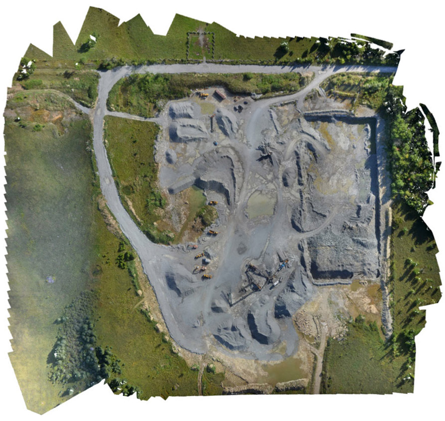
“We flew our Surveyor 630 over a total area covered by 3D data in one flight of 1,600m x 430m (69 hectares or 170 acres) I did 10 checks in the area with RTK GPS, all points (on the Z-axis) were under 3cm difference, half of the (Z-axis) points were under 2cm. This is a bigger area than I thought we’d ever cover (in one flight) with very strong results on positioning.”
Matt McGaghey
Survey Manager, HC&M
North American Construction Group
Land surveying is crucial to responsible land development, performing a variety of vital tasks such as boundary surveys, topographic mapping and construction staking. As such, data must be of an uncompromising high quality.
The data quality of photogrammetry is directly linked to the quality of the camera being used. At Infinite Jib™ we selected the correct DSLR camera and lens combination then we designed the aerial platform of our Surveyor 630 UAS. This approach is unique when compared to the majority of drones on the market that fly a camera selected to “fit” the drone’s size.
Utilizing Ground Control Points (GCP) the Surveyor 630 provides you with a solid foundation of accurate aerial data that then can be used to generate a range of reports with your post processing software.
Capitalize on a dramatic reduction in job times
Capitalize on a dramatic reduction in job times
High Resolution Orthomosaic
The Surveyor 630 has a flight time of approximately 20 minutes and is capable of completing a high-resolution survey approximately 650 metres long by 650 metres wide with 75% overlap in just 17 minutes. Infinite Jib™ clients frequently report that their projects are often completed well ahead of schedule.
Flight crews can rapidly deploy the aircraft from flight case to lift off in less than 5 minutes.
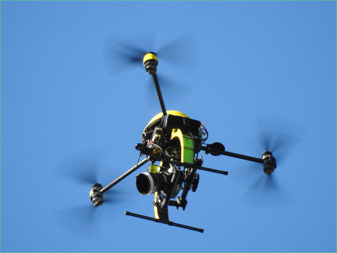
Design + Power + Size = Superior Wind Resistance
Infinite Jib™ UAV working in turbulent wind conditions
All UAV technology is sensitive to wind turbulence and the majority of drones will pitch and roll dramatically during wind speeds over 20 km/h (15 mph). Subsequently, many drone pilots spend time waiting until wind conditions are favorable (lower than 20 km/h (15 mph), to fly.
Fixed wing drone designs that mount the camera directly to the frame, are particularly impacted by turbulence. As wind levels increase the drone buffets, subsequently the camera is moved, which will degrade the survey quality.
The combined advantage of the aerodynamic design, size and power of Surveyor 630 UAV, with a two-axis stabilized camera gimbal, means that exceptional data is acquired in turbulent conditions that typically ground other drones. What our client’s value is having the ability to get the job done “right” when they need to stay on schedule.
Capitalize on a dramatic reduction in job times
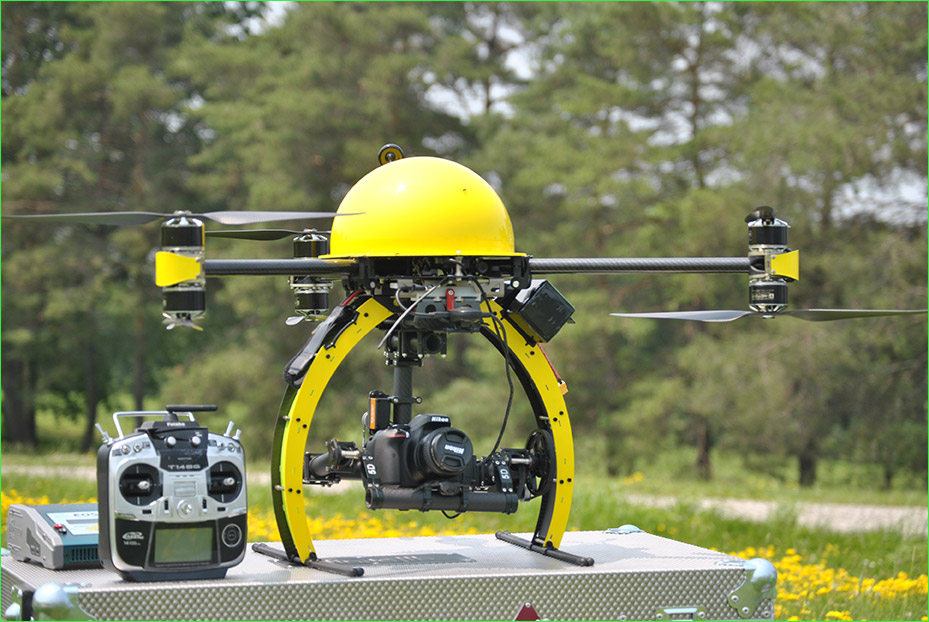
Surveyor 630 operating with custom 75mm lens for special inspection application
With any new, emerging technology, there must be an underlying expectation that “you” will learn with experience. It our opinion this outlook applies absolutely with our UAV equipment. Therefore, we incorporate a deliberate design advantage in our heavy lift aircraft to give you the potential to operate a wide variety of payload sensors, cameras or combination thereof. Our objective is that Infinite Jib™ clients have our support and options to expand their applications when opportunities arise.

Versatile Surveyor 630 customized to operate with Nikon 810

Proudly made in Canada

Designed, manufactured and serviced in North America exclusively for commercial applications, affords you with direct technical support and service from your aircraft manufacturer. We are a dedicated, specialized company that was founded in 2010. Over the years, we have become known for the exceptional performance of our aircraft, for providing prompt and effective support as well as for the genuine quality of our service.
Flight Crew not included but
everything else is standard
The Surveyor 630 is a comprehensive system built for
the professional pilot & crew:
Key Features include:
• Transport Canada Compliant Design
• Redundant safety systems
• Control flight operations transmitted either through the systems’ iPad or RC Radio
• Flight control functions include: Waypoint Programming, Manual Control, Return to Home, Auto Take-off and Landing, Position Hold
• Three on-board cameras, monitor flight direction and aid in data collection
• Rapid GPS acquisition for advanced and accurate route planning
• Integrated camera with remote shutter and GPS Geo-Reference images
• LCD monitor mounted on tripod displays live video from the aircraft
• Robust power system of battery packs, dual charger and AC/DC power converter
• The system swiftly packs down into a custom transport case.
• Comprehensive 2 part training program includes:
1. Three Day UAV Pilot Training Course presented by the Wellington Flight School provides you with practical, up-to-date information, so you can safely operate under Transport Canada's Exemptions
(under 1kg or 1-25kg) or under your Special Flight Operations Certificate (SFOC).
2. Two Day comprehensive aircraft operations presented by Infinite Jib provide you with a thorough overview of your UAV operations, mission planning, and hands-on flight instruction as well as maintenance procedures.


Compare Models:
• Surveyor 630 Photogrammetry UAS Solution
• Orion 700 Thermal / Photogrammetry UAS Solution
• Nexus 800 LiDAR / Photogrammetry UAS Solution
“With our Surveyor 630, we are capable a sub-centimeter precision when using ground control points”
Stephen Perry, PEng
Civil Engineer
Brunswick Engineering & Consulting Inc.


INTELLIGENT REMOTE SENSING INDUSTRIAL UAV SYSTEMS